Categories
Sale Item

2. Garmin Backroad Mapbook GPS Maps: Atlantic Canada V5, Micro SD Card

SKU: ACACSD
Price:
$99.95

Qty: - +
   - OR -   

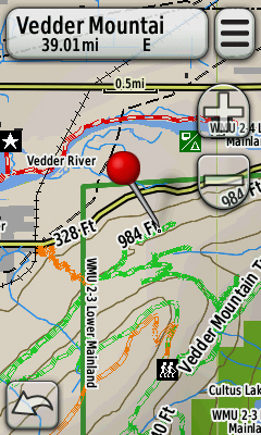
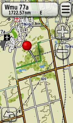
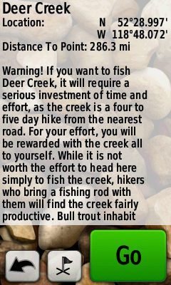
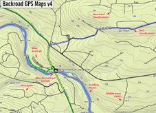
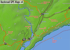
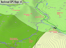
Combining Newfoundland & Labrador, Nova Scotia, New Brunswick and Prince Edward Island, these detailed recreational topographic maps load directly onto your Garmin GPS or MapSource/Basecamp! The new Backroad GPS map series gives outdoor explorers access to thousands of recreational points of interest, city and logging roads, trail systems and more. Whether you are hiking in the backcountry or exploring the Great Outdoors, the Atlantic Canada Backroad GPS Maps gives you the security of always knowing where you are, where you have been and where you are going. Great for camping, exploring, fishing, hiking, hunting, navigating, skiing and much more. Let us show you the way! 


Please make sure you can use cards 4GB or bigger in your unit.

Details:

Dimensions: Micro-SD Card

Map Scale: 1:10,000 & 1:50,000 scale TOPO Maps

Regional Cities/Parks: Provinces of Newfoundland & Labrador, Nova Scotia, New Brunswick & PEI

Backroad Mapbooks are proud to release their new Garmin GPS compatible line of maps. Now users can have access to our industry leading road and recreation maps in the palm of their hands. No other source offers as up-to-date backroad, trail and recreation data for all of Canada like we do. The Backroad GPS Maps also have the added value of detailed city and highway information to provide a safe and reliable product that will truly get you from your home to the Great Outdoors.


Features and Benifits:

  • Garmin GPS & MapSource compatible
  • More backroads, logging and industry roads than any other GPS source in Canada
  • Detailed trail systems, including defined ATV, snowmobile & long distance trails
  • 20,000 scale water features (BC & Ontario Only)
  • Geo-referenced backcountry Points of Interest & Recreation Features
  • Point specific wilderness campsites & recreation sites
  • Paddling routes including access points and portages
  • Search for Backroad Mapbook recreation information using the Whereto or Extras function
  • Wildlife management boundaries for anglers and hunters
  • City and highways information and points of interest
  • And much, much more

Note that all the standard Garmin GPS features like seemless topographic maps, the find tool to locate nearby city, water or recreation features and 50,000 scale geographic points are all part of the Backroad GPS Maps package.

With more roads and trails than any other source, people can finally get up-to-date backroad information on their Garmin GPS. We have also added in the many recreational features that have made Backroad Mapbooks Canada’s leading Outdoor Recreation source for over 15 years. Now people can navigate from their home to the backcountry with the confidence of a good road and recreation map on their GPS unit. 

    • Access to the most up-to-date Garmin GPS backcountry maps in Canada. We have become Canada’s source for the outdoors by providing current logging, industrial and bush road systems that emphasize recreational features. Finally, you don’t have to rely on the seriously out of date Canadian Topographic Maps!

    • Coast to Coast coverage. Whether you are in British Columbia or Nova Scotia, we have the maps you are looking for.

    • The clear choice for outdoor recreation. We provide everything you need to get you outdoors. The maps feature both city and industrial roads along with defined hiking and motorized trails as well as point specific recreation locations. Also unique to our product is the searchable Backroad Mapbook text in the Whereto or Extras feature of your Garmin GPS.

    • See map details like never before. We have combined Backroad Mapbook road, trail and recreation information with more detailed city and highway information to give you access to more information than any paper map can ever provide. GPS maps also have the added value of thousands of Point of Interest sites not shown on regular maps.

  • Made by outdoor enthusiasts for outdoor enthusiasts. We love what we do and it shows. Features like 20,000 scale water information, point specific wilderness campsites, paddling routes and wildlife management units are simply not available anywhere else.


Currently there are no reviews for this product. Share your opinion with others, be the first to write a review.

Add Your Review


Your Name:
Email Address:
Review:
Note: HTML is not translated! Your email address will not be shared with anyone.
Your Rating: 5
Verification:
Your Name:
Your Email:
Friends Name:
Friends Email:
Subject:
Message:
Verification: