| Your cart is currently empty |
| Subtotal: | $0.00 |
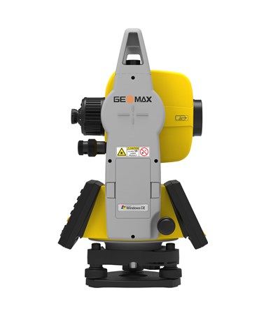
The Geomax Zoom40 Series Reflectorless Total Station is an advanced innovative Surveying piece of equipment, utilizing neXus EDM technology, with a measuring range of up to 1,640 feet without requiring reflection of a prism. Using a single prism, the Zoom 40 has an extended range of up to 11,483 feet. This Total Station features quadruple-axis compensation for reliable angle measurements.
This Geomax Total Station is equipped with a Bluetooth Class 2 for connecting with data collectors, a USB port for easy data transfer, and a high 2GB internal memory. The Zoom40 has a built-in laser plummet and a coaxial visible laser beam. Running Windows CE operating system, it offers onboard software flexibility which makes it compatible with popular surveying software, such as X-PAD, FieldGenius, and Carlson SurvCE (sold separately).
The Zoom 40 boasts a large 3.5-inch high-resolution colored touchscreen display, that comes with a full alphanumeric keypad. With an IP54 rating, this reflectorless Total Station is dustproof and water-resistant. As an additional feature, the Zoom40 uses a Li-ion battery with approximately 36 hours of battery life.
The Geomax Zoom40 Series Reflectorless Total Station offers two accuracies:
#865958 - GeoMax Zoom40, 2" WinCE Manual Total Station, neXus5 Reflector- and 500 m reflectorless EDM, 1 full alphanumeric keyboard with Q-VGA Color & Touch display, USB and USB Mini communication port, 1 USB Memory Stick, 1 Tribrach, 1 Battery, 1 Charger, 1 Charger Adapter, 1 pouch with tools, 1 Protective Cover, 1 Plumb Bob,1 Multilingual Quick Guide and 1 Carrying Case.
#865959 - GeoMax Zoom40, 5" WinCE Manual Total Station, neXus5 Reflector- and 500 m reflectorless EDM, 1 full alphanumeric keyboard with Q-VGA Color & Touch display, USB and USB Mini communication port, 1 USB Memory Stick, 1 Tribrach, 1 Battery, 1 Charger, 1 Charger Adapter, 1 pouch with tools, 1 Protective Cover, 1 Plumb Bob,1 Multilingual Quick Guide and 1 Carrying Case.
Features:
|
General
|
|
| Weight | 14.49 lbs (6.12 kg) |
| Dimensions | 16” L x 8.27” W x 6.69” H |
| Warranty | 1-year |
| Protection Class | IP54 dustproof and water spray resistant |
| Tripod Thread | N/A |
| Auto Shut Off | N/A |
| Internal Memory | 2 GB |
| Software | GeoMax X-PAD, GeoMax FieldGenius, and Carlson SurvCE (sold separately) |
| Tribrach | Yes |
| Auto-Tracking Speed | N/A |
| Guide Light | N/A |
|
Angle Measurement
|
|
| Measuring Method/Reading System | Absolute, continuous, diametrical |
| Detection Method | N/A |
| Minimum Reading | N/A |
| Accuracy | 2-second, 5-second |
| Diameter of Circle | N/A |
| Display Method | 0.1” / 0.1 mgon |
|
Distance Measurement
|
|
| Unit of Measure (distance display) | m/ft |
| EDM Accuracy (Precision) | ±2mm + 2ppm |
| Minimum Reading | Up to 1,640 ft. (500 m) |
|
Tilt Sensor/Compensator
|
|
| Range | N/A |
| Type | Quadruple-axis compensation |
| Method | N/A |
| Setting Accuracy | N/A |
|
Battery/Power
|
|
| Power Source | Removable Li-ion |
| Battery Life | Up to 36 hours (continuous angle); Up to 16 hours (continous distance measurement every 30s) |
| Battery Life Alert | N/A |
| Voltage | N/A |
|
Optical Plummet
|
|
| Image | N/A |
| Magnification | N/A |
| Field of View | N/A |
| Focus Range | N/A |
|
Level
|
|
| Plate/Tubular Bubble Vial | N/A |
| Circular Bubble Vial | N/A |
| Electronic Level | N/A |
|
Telescope
|
|
| Length of Tube | N/A |
| Image | N/A |
| Diameter of Objective Lens (Aperture) | N/A |
| Magnification | 30x |
| Field of View | 1° 30' |
| Resolving Power | N/A |
| Minimum Focus Distance | N/A |
| Ratio of Stadia Lines | N/A |
| Sight Distance Precision/Focus Range | N/A |
| Reticle Illumination | N/A |
| Reflectorless | N/A |
| Quick Sights (Rough Sights) | N/A |
|
Display and Keypad
|
|
| Type | Q-VGA color & touch display |
| Sides | Single |
| Keys | Full alphanumeric |
| Touchscreen | Yes |
| Backlight | Yes |
| Pixels | 320 x 240 |
|
Temperature
|
|
| Operating | -4 to 122 °F (-20 to 50 °C |
| Storage | N/A |
|
Applications
|
|
| Surveying and Construction | Yes |
| Mapping and GIS (geographic information systems) | Yes |
| Utilities | Yes |
| Environment Studies | Yes |
| Geomarking | Yes |
| Archaeology | Yes |
| Accident Reconstruction | Yes |
|
Measurement Range (under fair weather conditions)
|
|
| Single Prism | Up to 11,482.94 ft. (3,500 m) |
| Triple Prism | N/A |
| No Prism | Up to 1,640 ft. (500 m) |
| Mini Prism | N/A |
| Reflective Tape | N/A |
| Reflector Sheet | N/A |
| Cat Eye/Flat Prism | N/A |
| 360 Degree Prism | N/A |
|
Functions
|
|
| Coordinate Measurement Point | Yes |
| Angle and Distance Stake Out | Yes |
| Stake Out Line | Yes |
| Offsets | Yes |
| Missing Line | Yes |
| Remote Elevation | Yes |
| Resection | Yes |
| Area Calculation | Yes |
| Real-Time Video Imaging | No |
|
Measurement Time
|
|
| Fine | N/A |
| Rapid | N/A |
| Tracking | N/A |
|
Laser Plummet
|
|
| Accuracy | 1.5 mm at 1.5 m instrument height |
| Class | Class 2 |
| Wavelength | N/A |
|
Laser Pointer
|
|
| Class | N/A |
| Accuracy | N/A |
| Laser Range | N/A |
|
Interface
|
|
| Bluetooth | Class 2 |
| USB | Yes |
| Pin Port | N/A |
| Operating System | Windows CE |
|
RC-PR5 Remote Control System
|
|
| Operating Range | N/A |
| Measuring Time | N/A |
|
Auto-pointing
|
|
| One AP Prism | N/A |
| Reflective Sheet | N/A |
| 360 Degree Prism | N/A |
| Mini Prism | N/A |